Mobile optimized maps with GPS locator
Your maps, on any device
Whether you're on the other side of town or the other side of the world, take your maps with you. BatchGeo's mobile-optimized maps look good and works smoothly on any device with a web browser. Even better, we'll use GPS to provide you and your customers with contextual maps that change based on your location.
Want to create a map that automatically routes mobile users to the nearest location? Our service has this built in to every map created. You don't need to do anything special to give your map a mobile version. Just follow the simple steps on BatchGeo to create a mobile-optimized locator map.
We've taken extra care so that our maps work on desktops, laptops, and every phone and tablet platform. Specifically, we tested BatchGeo on these mobile devices:
- iPhone and iPad (native app)
- Android
- Blackberry
- Windows Phone 7
We will optimize BatchGeo for all mobile platforms as they are released. Let us know if we're missing your device.
Try our mobile maps for yourself
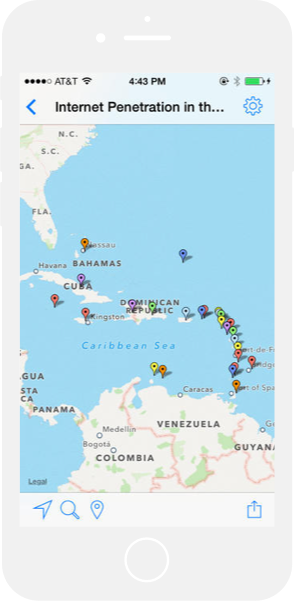
The absolute best way to appreciate BatchGeo's mobile maps is to make one yourself. The second-best way is to view one of our sample maps on your mobile device. Check out this map of US National Parks.
BatchGeo is made to automatically size itself to the appropriate dimensions of your mobile device, so you might even think you're using a native app. Adding to that illusion is the slickness of the zooming and panning. If you approve access to the GPS, the map will even start in your vicinity and mark your exact location.
Share mobile maps with your team
It's great to use BatchGeo alone, but it's even more powerful when you can share it with your team—or your customers. Sharing your mobile maps is easy because the web address, or URL, is the same as the non-mobile version. By employing responsive design, we automatically render maps specifically to your device.
To share a public or unlisted map:
- Copy the URL from the location bar using Ctrl+C (Cmd+C on Mac). For example: batchgeo.com/map/national-parks
- Paste that URL in an email, text message, or on a social network
That's it! No matter what device the recipient uses to view your map, they'll have a good experience.
Mobile app
Pro users can also share maps with their team, as well as password protect on a per-map basis.
For easy access to all of your maps, and even better performance, consider the BatchGeo native app.
Frequently Asked Questions
What is BatchGeo and how does it work?
BatchGeo is a free online mapping tool that turns spreadsheet data into interactive Google Maps. Simply copy your data from Excel, Google Sheets, or any spreadsheet, paste it into BatchGeo, and click "Map Now." We automatically geocode addresses, city names, zip codes, and coordinates to place your data on a map.
Is BatchGeo free to use?
Yes, BatchGeo offers a free tier that lets you create maps with up to 250 rows of data. For larger datasets, advanced features like password protection, and ad-free maps, BatchGeo Pro plans start at $99/month.
What types of location data does BatchGeo accept?
BatchGeo accepts full street addresses, city and state names, zip/postal codes, latitude and longitude coordinates, IP addresses, and even landmark or business names. We support data from over 200 countries worldwide.
Can I embed a BatchGeo map on my website?
Absolutely. After saving your map, you receive embed code that works like embedding a YouTube video. Just paste the HTML snippet into your website, blog, or CMS. The map is hosted on BatchGeo servers and displays seamlessly on your page. Learn more about embedding maps.
How do I share or update a map after creating it?
Every map gets a unique URL you can share via email, social media, or messaging. To update your map, use the edit link sent to your email when you saved the map. You can modify data, change settings, and re-save at any time. See our guide on editing map data.